


| | | | The Alps: Mt Blanc & the Haute Route |
Photos and text by Jonathan Carr
200km walking across Switzerland... and a few hills along the way (some 11 000m of up-hill)... here is a modest selection of... errr.. 140 slides!
There are 3 pages with small pictures with links to big ones... Click on the small pictures to get BIG pictures... or follow the slide show arrows (where pictures are presented in order) by pressing the arrow at the bottom of the page. Alternatively, check out the index. Beware! you need as many colours free as possible - run netscape or whatever with its own private colour map... better still use another viewer for the images (Netscape is terrible)... or even better get a 24-bit monitor!
Apologies for naming mistakes - I'll have to find a map!
 | The Haute RouteTo finish off the walk we leapt up Mt Blanc. This was relatively easy after the acclimatisation of the Haute Route.... Of course, there's more to the Haute Route than snow and summits. Along the way we passed by alpine tarns, wandered through meadows, forest and encountered sheep and cows with bells on. Then there were the cuckoo-clock houses, the alpine villages, small mountain chapels ...real sound-of-music stuff, and then of course, the welcoming, but expensive, cafes and cabanes! |
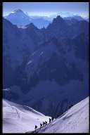
WeatherUnfortunately, the weather wasn't great and our summit views consistently resembled the inside of a cloud! But you get that.A short rambleWe began in Chamonix but soon escaped to Argentiere and spent the first night at the Albert premiere cabane - perched next to the glacier. The next day we traversed the Plateau du Trient - the weather was a bit doubtful to start with... but it improved... culminating that night with a great sunset above the clouds (3400m). The cabane du Trient was my first experience of a Swiss cabane - complete with cuckoo clock.. The resident family offered fresh baking and live music... not bad at 3000m.Excellent weather the following morning allowed us to make a leisurely 2000m descent in to Orsieres. We had a quiet stay in Bourg St Pierre that night (relatively cheap!). Early the next morning we set off for the 1500m+ climb up to the Valsorey. At first it was light rain, then it turned to snow... but there were some great views of Mt Valen along the way! A grim 2-night stay in the cabane Valsorey followed. Despite an abundance of gear catalogues, it was a bit cold up there (catalogues don't burn well). The guardian attempted a landing by helicopter but failed due to the wind and snow. The next morning I mis-loaded my compact camera and lost the best pictures of the entire trip(!) as we crossed over the Plateau du Couloir - the so called crux of the Haute Route. It was a bit dodgy due to the uncertain weather and the route up to the Plateau from the hut was riddled with fresh avalanche tracks. Hmm... there were some excellent spin drift shots at the top of the exposed 3700m pass. Things looked a lot brighter on the other side as we by-passed an ice-fall on our descent. The route to the summit of the Grand Combin looked like it would have been a goer in better snow conditions. By the time we got down in the valley the weather had closed in again. The night was stormy with lots of electrical activity (apparently it was very impressive - but not as impressive as Germanic snoring). The roof of the cabane leaked like a sieve and an impassable torrent was coming out of the glacier up the valley... so we retreated with the guardian down the valley, ..clearing rocks and debris off the road and briefly visiting a 2-300m? high barrage down in the valley (they base-jump off it!). After hot chocolate in a traditional hotel it was off to civilisation (P...) before heading to Arolla.. by bus! We stoped at a wonderful village along the way and had ice creams as the rain cleared to reveal an awesome day. Thus, we by-passed the big glacial snow-plod to Arolla - however, we made up for this by ascending the Pigne d'Arolla (in soft snow) and checking out the ?? glacier. First we spent a night at the dramatically located Cabane des Vignettes - notable for it's very long, long-drop. I remember the last bit being a tough snow-plod - no tracks... and we were the only ones in the cabane.. until the guardian arrived (then it was "Married with Children" at altitude!). From here we climbed la Pigne d'Arolla (3794m) which gave us our first cloud-shrouded views of the Matterhorn. Then we dropped back down into Arolla through some wonderful alpine meadows. I leaped up over another pass into the ..? glacier and the ...? cabane. The Pass id well known for its 50-70m of fixed iron ladders which drop down on to the ... glacier. The next day was the climb up to Cabane Bertol - there's an interesting approach on fixed ropes and ladders up to this fortress-like cabane. Then the weather returned to haunt us yet again! - a white out turned us back the following day... the next day was initially better and we accompanied a guided group over the ..? Dramatic lighting, if not views! - very atmospheric. We plugged steps up the 700m of climbing to .... The visibility on the glacier was poor and negotiating the crevasses on our way down to Zermatt would have been very difficult without the guide's local knowledge. It was a snowy stay that night at the cabane ..?. We still hadn't seen the Matterhorn! The next day it was still snowing as we followed the glacier moraine wall down towards Zmutt. At the last minute we decided to head high and avoid the town for another night of altitude.. and hopefully views the next morning of the local Peaks. The Hotel du Trift was nicer and cheaper than staying in Zermatt. There was a neat little sound-of-music chapel nearby. From here we made an ascent of the Mettelhorn - again in hope of a view. It was an easy scramble but there was still no view! We descended the Mettelhorn down to Zermatt (legoland). There were still very few walkers about and the trail past by alpine streams, through forest and meadows... and a cafe too. A welcome change from days of snow. At last! A brief view of the Matterhorn from the town.
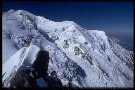
The next morning provided superb views of the sunrise... from the YHA! We headed off for our first 4000m peak - the easily accessible Breithorn. The summit ridge was a bit breezy. Great views of the Matterhorn and Mt Rosa.
| |
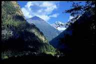
Aiguilles RougesWe relaxed the following day by walking and exploring in the Aiguilles Rouges... lakes, peaks, mirror reflections and forest - no snow for a change! Even the rain was enjoyable after 3 weeks of snow.On the last day we went for an early morning trip up the Aiguille du midi for some great views of the Aiguilles du Chamonix... it had to be done... next time I'll give the parapenting a go! That afternoon we headed back to England in a very uncomfortable bus. | |
|
 |
| Mt Blanc... (68k) | Gorges du Trient! (61k) |
Rejoignez
le Webring sur Zermatt
de Jonathan Carr.
[
les 5 précédents
|
précédent
|
au hasard
|
suivant
|
les 5 suivants
|
tous les sites
|
S'inscrire]