| Tongariro National Park |
Photos and text by Jonathan Carr
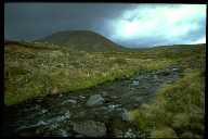
| One of the first National Parks in the world, (2nd or 3rd after Yellowstone), Tongariro is also a World Heritage Site. The obvious feature of the park are the three active volcanic cones of Ruapehu, Ngauruhoe and Tongariro. Lesser dormant vents include Mt Pihanga, Kakaramea and Mt Hauhangatahi. The core of the Park was gifted to the then Queen Victoria by the Maori chief Te Heuheu Tukino IV - paramount chief of the Tuwharetoa and a man of extraordinary foresight. He did this to protect the mountains sacred to his people.
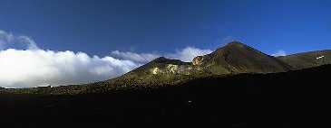
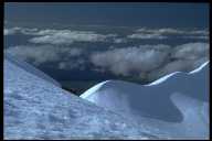
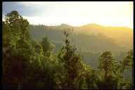
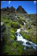
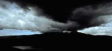 Mt Ruapehu - Summer storm (14k) Mt Ruapehu (2797m) features a summit plateau with peaks protruding over 9000ft. There are seven small glaciers (read permanent ice). The main feature is the highest, and more recently hottest, lake in New Zealand - the Crater Lake which disappeared in June this year (1996) after the mountain went into eruption. Ruapehu has the largest ski field in the country which is partly responsible for the million visits which this park gets per year. Ruapehu is capable of providing some of the best and most accessible ice climbing in New Zealand and is more reliable than the South Island (so I've heard). The Crater Lake used to attract swimmers who would ski up and go for a dip. However, the grey/black sulphur slicks of recent years do not make this so appealing. Furthermore, access is difficult since much of the lake is ringed by 10-20m ice cliffs. The lake used to discharge through a subterranean ice cave. Lahars from the lake are a real threat - on Christmas Eve 1953 a rail bridge was swept away at Tangiwai by a lahar from the lake, moments before the Wellington-Auckland train was to cross - the worst NZ volcanic disaster this century, it claimed 151 lives. The Tarawera eruption of 1885 is NZ's worst eruption to date (at least recorded). Mt Ngauruhoe (2200m) is the strikingly conical mountain to the north of Ruapehu. It is really a young vent of Tongariro. It features a double crater and has erupted spectacularly in the 1950's, 70's and been smoking off and on since. Mt Tongariro (1900m) looks like a lumpy thing to the north of Ngauruhoe. It is perhaps the most interesting of the mountains and features a complex collection of craters. The Emerald lakes are filled with brilliant blue-green water (from dissolved sulphur compounds). Bright coloured red, ochre rocks mix with black scoria. Red crater still steams away happily, while the Kekatahi hot springs attract many tourists and trampers. Kekatahi is actually an oasis of Maori land on the northern slopes of Mt Tongariro (it offers great views north over lake Taupo). The local tribe retains the right of access by horse. Future access to the springs by the public may be restricted. The day walk traverse across the craters of Tongariro is claimed by the locals to be the best day-walk in the world, and I think they may be right! A large desolate saddle separates Ruapehu from the northern mountains. This contains the large explosion craters of the Tama lakes. The Eastern slopes of the Park form the Rangipo desert - one of my favourite places - and unique in New Zealand. There is also an underground power station nearby. Rafting the Tongariro river is another attraction... when Electrocorp turns on the water. The Tongariro power scheme is an amazing piece of engineering - a network of hydroelectric canals and tunnels ring the park and divert 90% of the water from the mountains into Lake Taupo. However, the scheme is of dubious net benefit to the country in terms of its affect on water catchments and ecology. Geothermal power is generated further north at Wairakei and Ohaaki, beyond Lake Taupo. The photos on this site were all taken on a single 3.5 day trip! |