


| | | Mt Tapuaenuku, Inland Kaikoura Range |
 |
|
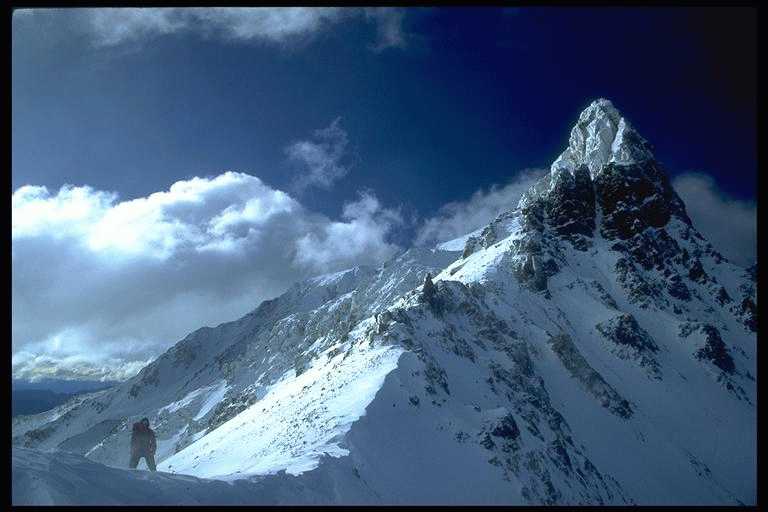
Winter Nor'west conditions at about 2500m on the saddle between Mt Alarm and Tapi (2885m) - the highest mountain in NZ outside the Southern Alps. The Kaikoura ranges lie on the dry east coast at the top of the South Island in a geologically active region. The dry conditions and rapid uplift of the area account for the height of these ranges. The summit is occluded in this view (looking north) by a gendarme which can be easily skirted around either on the Hodder side (left) or the Clarence side (right). The Clarence river separates the Inland and Seaward ranges - the latter rise dramatically from the sea to a height of 2600m in almost as many metres from the coast. A tramper's mountain - Tapi offers technically easy walks for beginners and views from Christchurch in the South, to Wellington in the North Island and Mt Owen in the west... depending on the weather! The South (Clarence) face of Tapi may offer a challenge in winter for the rare few who try.
An unusual feature of the Kaikoura ranges is the occurrence of rock glaciers. Beneath the scree lurks slow moving ice. Consequently, the scree takes on the features of glacial moraine. This occurs because precipitation is insufficient to produce permanent surface ice but the mean temperature is sufficiently low. Rock glaciers also occur in the dry Two Thumb Range north of Mt Cook. |
|
Kaikouras overview | Tapi in a day from the Clarence river | Back to Jonathan's gallery Copyright (c) 1996 Jonathan Carr |